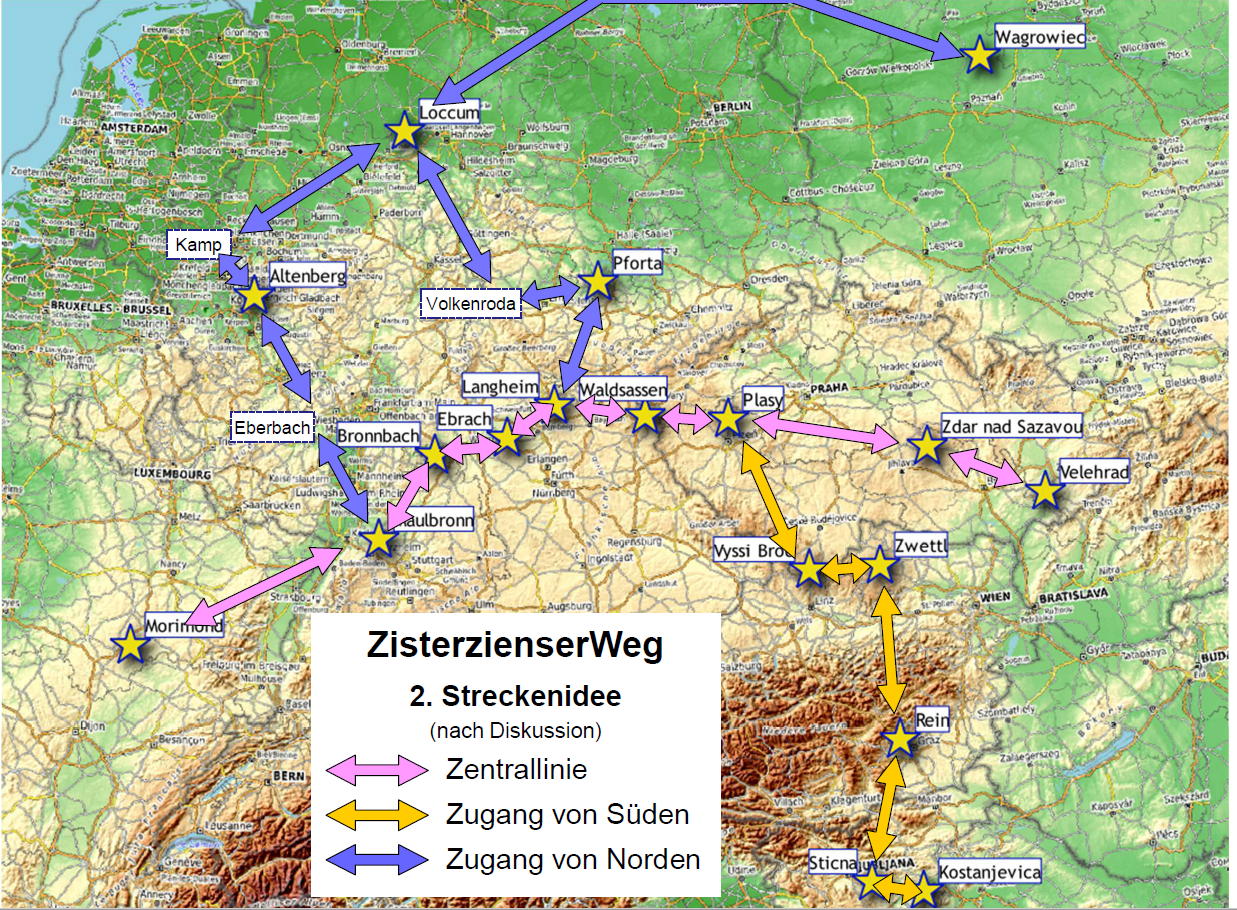
Europe-wide route network
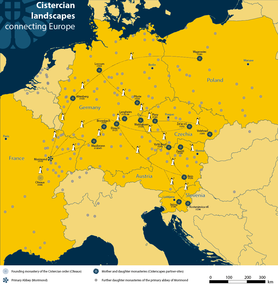
Founded shortly before 1100, the Cistercian order quickly spread throughout Europe with a network of mother and daughter monasteries. A dense network of paths, which was oriented towards the original monastery in Cîteaux in French Burgundy, connected the abbeys with each other.
Cistercian monks traveled a lot. Once a year, all abbots met at the mother monastery of Cîteaux in Burgundy, France, for the general chapter. There were also regular visits between the mother and daughter monasteries, known as visitations. visitationsduring which the abbots of the mother monasteries or their representatives visited their “daughters”(filiations). Granges, town courts and official residences also had to be visited regularly. This travel activity played a central role in the organization of the order and the transfer of knowledge.
Map: Across Europe – a dense network of paths connected the Burgundian mother monasteries with all their daughters.


On the trail of the monks
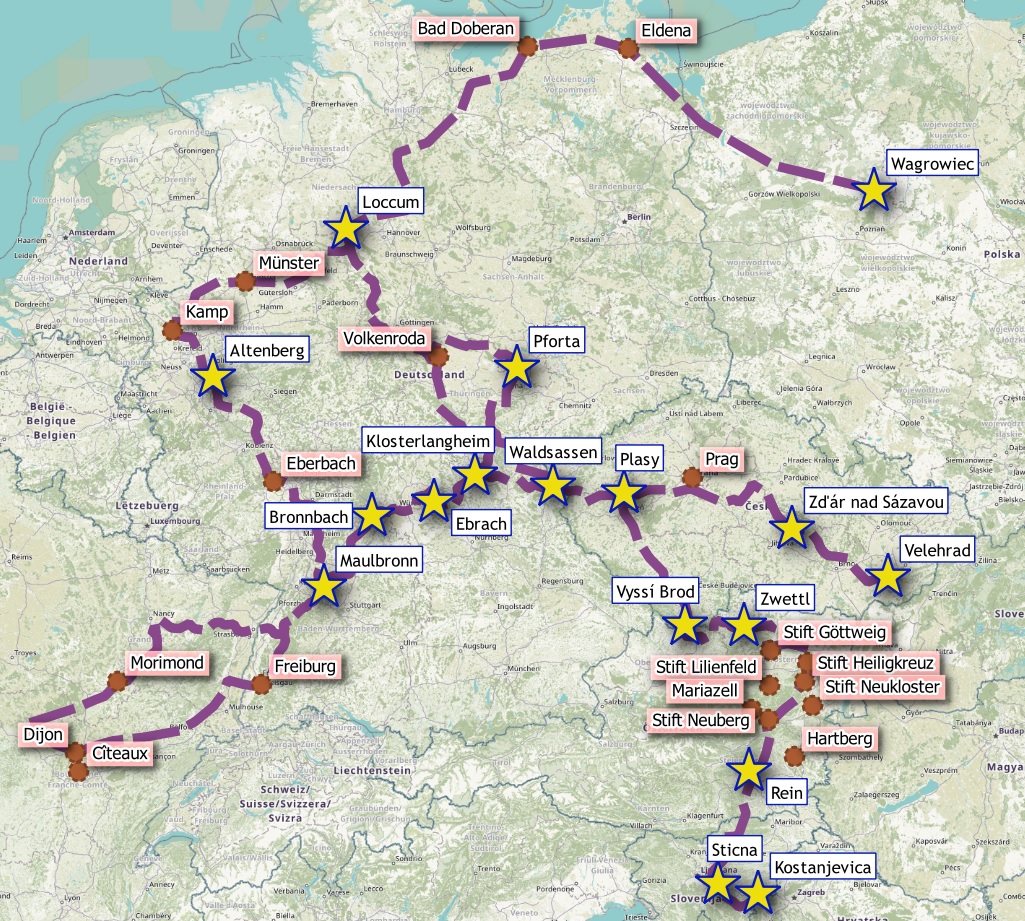
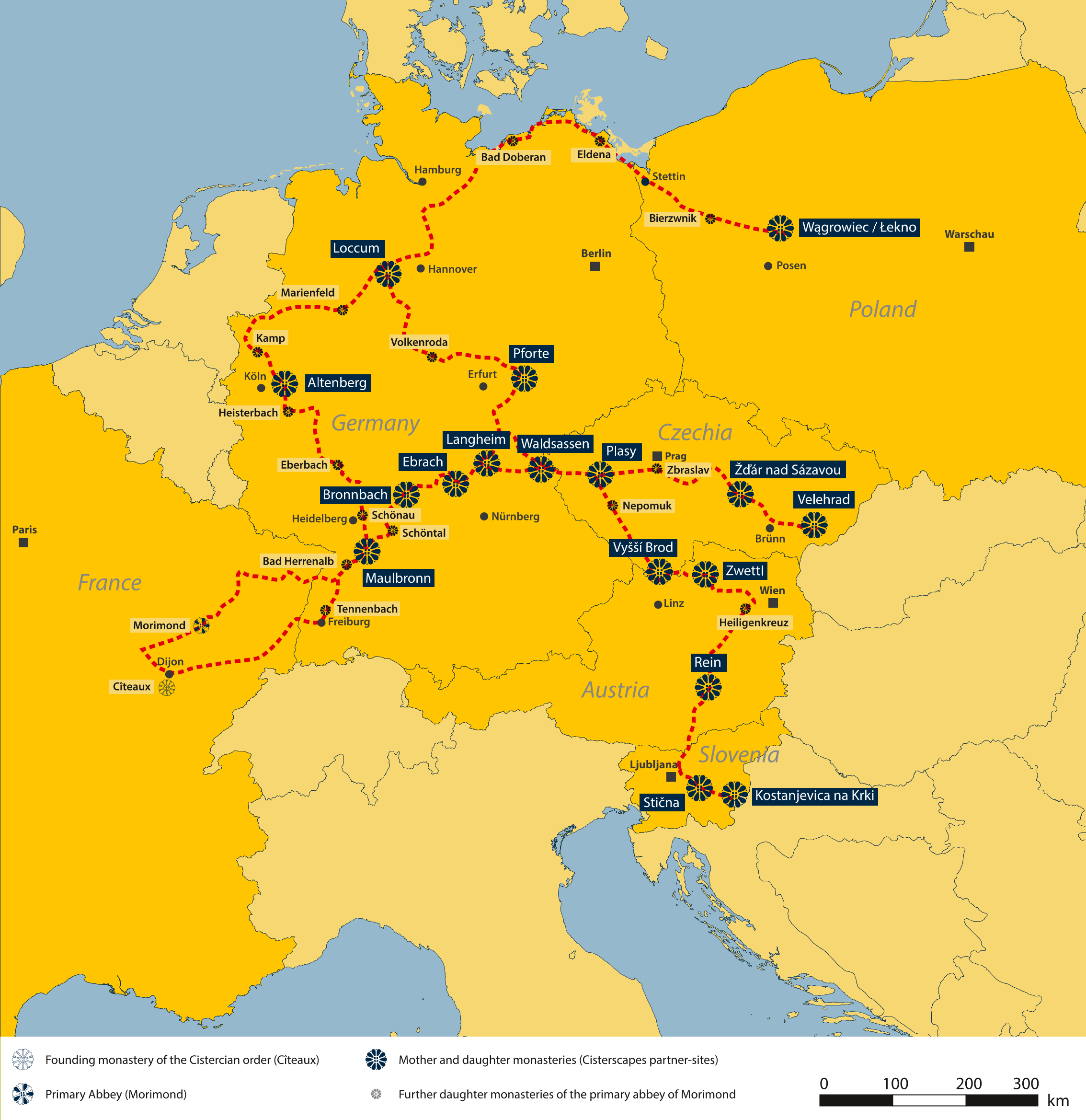
Discover the approximately 6,400 km long “Cistercian Way” cultural hiking trail. This connects monasteries, landscapes and people in six countries.
In addition to the long-distance hiking routes, there are also other local hiking and themed trails of varying lengths at the 17 monasteries in the Cisterscapes network. All trails are wonderfully walkable!
You can find the tours on our outdooractive map below.

View from the panorama trail into the middle Ebrachtal © Thomas Büttner

Cistercian Way
The Cistercian Way is currently a 6,400 km long cultural hiking trail that runs through six European countries and primarily connects the 17 monastery landscapes of the Cisterscapes network via three lines (Central Line, North Line and South Line). The conception and planned continuation of the trail is a central measure of the Cisterscapes project. Planning by the Hans-Georg Sievers hiking office began in 2020 and the trail itself was opened in 2022 at a central event in the district of Bamberg. Further sections of the trail were published until 2024. In addition to the project partners, numerous hiking and tourism associations were also involved in the design.
The “Cistercian Way” long-distance hiking trail runs along existing, already marked hiking trails and can be accessed along the entire route via the outdooractive app. The special symbol “marker change” helps you find your way around.
We recommend installing the free outdooractive app (see www.outdooractive.com); please use the “Long-distance hiking trails” filter in the tour search.
You can find further route planning options in our download area:
– gpx data of the main routes
– Hiking maps with detours as PDF
Our sections with all detours, shortcuts and interesting
intermediate destinations are also available at www.outdooractive.com (please use the “Long-distance hiking trails” filter in the tour search). We recommend installing the free Outdooractive app.

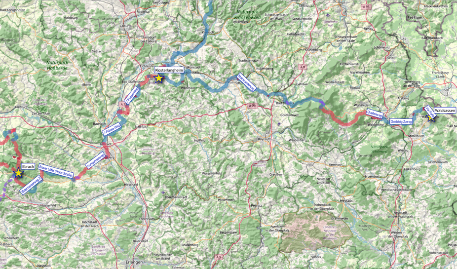
Bavarian section
Cisterscapes on Geoways:
Cisterscapes tour portal
Experience the monastery landscape on extensive walks and easy hikes of 6-9 km in length: We provide you with circular routes around the monasteries of Morimond, Ebrach, Waldsassen, Rein, Vyssy Brod, Zwettl and Plasy with interesting descriptions of the monastery landscape, GPS routes and download via outdooractive.
Would you like to follow the path of the Cistercians? Here you will find the complete long-distance hiking trail.
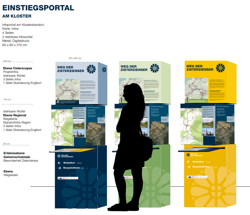
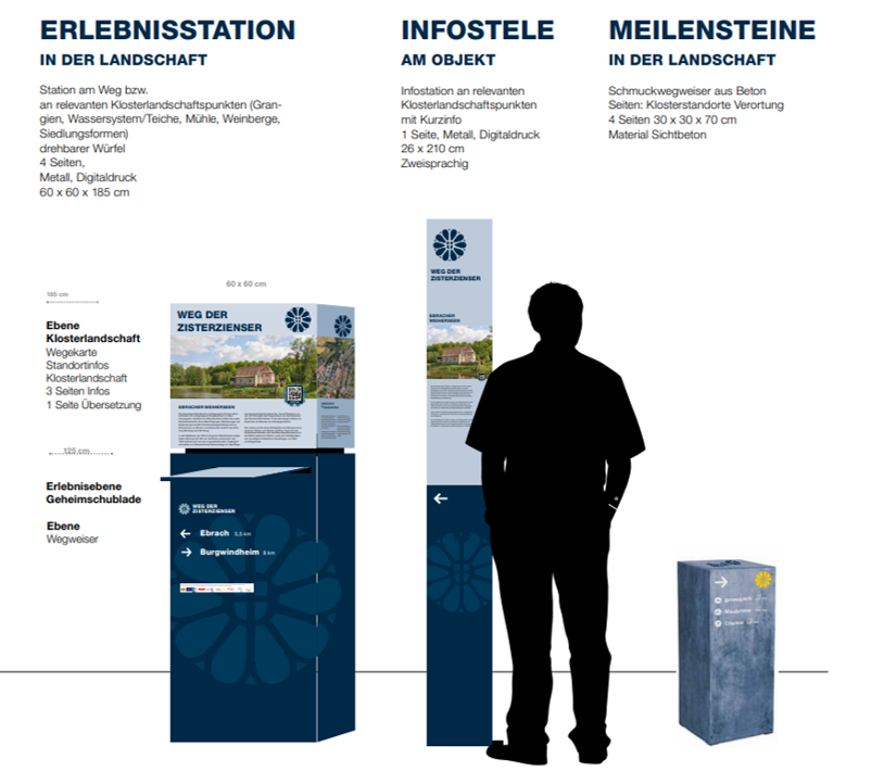
Info on site
A specially designed hiking information system can be found along sections of the route. It was set up as a model at over 40 points in the Bavarian monastery landscapes of Ebrach, Langheim and Waldsassen. In the meantime, numerous other Cisterscapes partner sites have also implemented this system. The information elements are located at the monastery (three-part system) or directly at important landscape elements.
Making of “The Cistercian Way”
The idea behind the concept for the long-distance hiking trail across Europe
The long-distance hiking trail, which has connected the Cistercian monastery landscapes in Germany, Austria, Poland, Slovenia and the Czech Republic with the original monastery of Cîteaux in France since 2022, was designed as part of the transnational LEADER cooperation project “Cisterscapes – Cistercian landscapes connecting Europe” between 2019 and 2022. The model for this route is the regular journeys and visitations between the monasteries that have taken place since the order was founded in 1098, as well as the important journey of the abbots to the annual general chapter in Cîteaux. In addition to this spiritual connection, the monasteries were also involved in administrative and economic exchange. The Cistercian Way is intended to revive this transnational network and thus the experience of culture and landscape!